We’ve Put Firefighters on the Map – Map View Now Available in FireGrid™ Monitor
-
 Supplied-Air Respirators
As part of MSA’s Connected Firefighter Platform, FireGrid Map View improves Incident Command’s situational awareness through monitoring advancements.
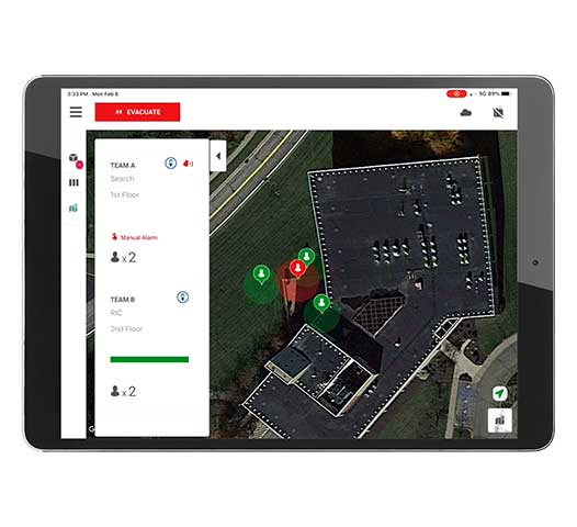 As part of MSA’s Connected Firefighter Platform, FireGrid™ Map View improves Incident Command’s situational awareness through monitoring advancements. This leading-edge technology leverages the GPS capability in LUNAR® Connected Device, which puts firefighters on the map, allowing Incident Command to monitor their crew’s estimated location in FireGrid Monitor, MSA’s tablet-based local monitoring application.
Map View provides:
- Live monitoring for incident commanders and departmental leadership
- Estimated location outside a structure
- Selectable marker information-personalization
- Status denoted by marker color
- Last known location/GPS connection lost indication
- Three selectable map views — satellite, default, terrain
Update your LUNAR® Connected Devices to the latest firmware, and update FireGrid Monitor to the latest version to begin experiencing Map View.
Read more about Connected Firefighter here.